
The written version
What makes a site well related to a village
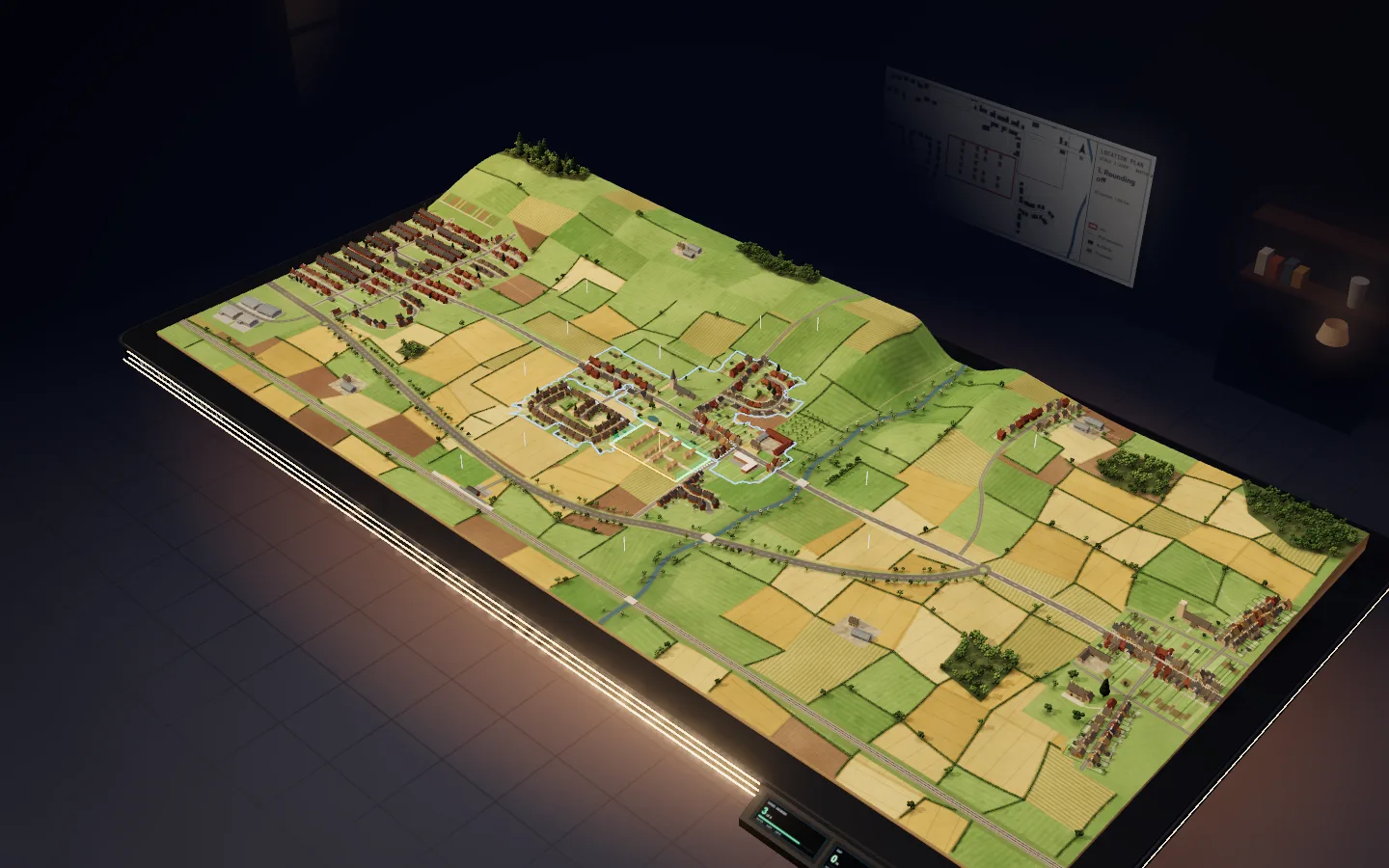
Several policies in the National Planning Policy Framework (2026) let building outside a settlement go ahead if it is physically well related to one. The Framework never defines the phrase, so it is settled site by site, as a matter of judgement. These are the things that judgement usually turns on, shown on one model village of 192 homes and thirteen fields round its edge.
Where the phrase appears
The same words do slightly different work in each policy: what the site must relate to, whether simply adjoining is enough, and whether the walk counts.
Policy · S5(1)(j)(i)
Housing to meet unmet need
Outside settlements, development that addresses an evidenced unmet need, such as a council that cannot show a five year supply of housing land, can be approved where it is physically well-related to an existing settlement (unless the nature of the development makes that inappropriate) and of a scale that can be accommodated. Most edge-of-village housing goes this way.
Policy · S5(1)(h)(ii)
Homes near a well-connected station
Homes within reasonable walking distance of a well-connected station can be approved where they are physically well-related to the station or to the settlement the station is in. A site can lean on either. GB7(1)(h)(ii) asks the same question in the Green Belt.
Policy · HO10(2)(a)
Rural exception and community-led sites
Exception sites for affordable or community-led housing outside settlements should adjoin or be physically well-related to a settlement. Adjoining is enough on its own. Unless the plan says otherwise they should also stay within one hectare of built development or 5% of the settlement's size, whichever is greater.
Policy · E4(2)(a)
Business needs in rural areas
Where a rural business needs to be outside a settlement, proposals should take the chance to use sites physically well-related to existing development. Any buildings count, so a hamlet or a farmstead will do. E4 accepts that such places may not be well served by public transport, so the walk is not weighed.
Policy · HO12(1)(a)
The one place it is turned round
For traveller sites, HO12 recognises that working from home can reduce travel, so locations not well related to existing settlements may be appropriate. It is the only policy that says so.
What counts as the settlement
The village
The old village
About 192 homes, a church, a school and a shop. The Framework's glossary defines a settlement as a city, town, village or other predominantly built-up area, including land allocated or with permission that will form part of it once built. Hamlets and scattered groups of houses do not count unless the plan names them.
The local plan
The settlement boundary
The line the local plan drew round the village. Mill Meadow was built after it with planning permission, so it sits outside the line though it is plainly part of the village. The glossary counts land with permission as part of the settlement, so the line on paper is only part of the story.
The local plan
Allocation H4
Land east of the brook that the local plan allocates for 30 homes. The glossary counts allocated land as part of the settlement before anything is built.
The land
The hamlet
A dozen houses and a farm high up Moor Lane, about 300 m from the village and from the next village. A hamlet is not a settlement unless the plan defines one, though E4 counts it as existing development.
Footnote 28
Beyond an allocation
Where a site is outside a settlement and cut off from the built-up area by an allocation that has not been built, footnote 28 asks decision-makers to consider whether it would still be a suitable location if the allocation never went ahead.
Policy · S3(2)
Across the line
A site that is partly inside and partly outside a settlement is read in two parts: S4 for the part inside and S5 for the part outside, before an overall view is reached.
Nine things decisions weigh
None of these is a test on its own, and no policy gives them weights. A site can do well on most and still be refused for one, or the other way round.
Factor · Sides bounded
How many sides meet the place
The usual starting point is to walk round the site and count the sides that meet houses and gardens. With three or four, a site is almost enclosed; with one, it can read as a bolt-on. The count means different things in different villages: along a lane where the houses stand one plot deep, one bounded side is normal. Houses across a village street bound a side. Open space such as the green encloses less than houses do.
Factor · The gap
What is left between
How far the site is from the nearest gardens when it does not touch them. A narrow strip of other land matters more than its width suggests, because the scheme cannot join up with the village unless that land does too, and its owner may never sell.
Factor · Between
Lines on the ground
Some features hold a village in: a bypass, a railway, a river. Building on the far side of one of them tends to read as a new place, however close it is in metres. A road only separates where it marks the edge. With houses on both sides it is a village street, and part of the place.
Factor · The edge
What kind of edge it meets
Where the village stops, look at how it stops. A loose, organic edge, with gardens of every depth and houses at different distances from the centre, can take a little more without changing its character. A hard edge, where the houses stop together along a clear line, is much harder to break, and a scheme that juts out beyond one is what planners call a pimple. A site in a pocket that the edge already wraps round rounds the village off.
Factor · The outer edge
What would mark the new edge
When the village grows, something has to hold its new edge. A road, a railway, water or a belt of mature trees gives a firm and lasting line. An established hedgerow is a recognisable boundary. A line drawn across an open field has nothing on the ground to hold it, and new planting takes years to read as an edge.
Factor · Grain
Whether it fits the way the place grew
In practice the core question is whether the scheme fits the grain of the village and would read as an unremarkable part of it. A village round a green, a village strung along a lane and a planned estate each have their own grain. A row along a lane continues a linear village; homes reached down a drive behind other houses cut across one. The layout matters as well as the site.
Factor · Scale
How big beside the village
A handful of homes is absorbed by a village. An extension that adds a quarter or more changes what kind of place it is. S5(1)(j) also asks separately whether the scale can be accommodated, taking account of schools, roads, drainage and the rest of the infrastructure.
Factor · Landform and views
How it sits in the land
On level ground behind houses a scheme reads with the village. On a slope it shows from further away, and at the crest of a hill it breaks the skyline. Trees along the open side soften the view. The landform stays the same, so planting helps most where the land is already kind.
Factor · Walking in
Whether people can walk to the shop
The policy's words are about a physical relationship, and decisions often look at walking routes as part of it. A footway that runs all the way to the shop and the school shows a site joins up with the place. A road with no footway, or a bypass to cross on foot, shows that it does not.
In practice
Draw the red line round the homes
The red line and the area where homes would go are often different. Judge the relationship where the houses would actually stand. If they would sit in the corner of a big field that relates well, a red line drawn tight round that corner is usually a stronger application than the whole field, as long as its new outer side gets a proper boundary.
What the form of the village changes
Sides bounded and edge character mean different things in different villages. The model village has several forms at once: a core round the church and green, a lane one plot deep, two planned estates and a scattered hamlet. Each field is read against the part it adjoins.
Form · Nucleated
Grown round a centre
A church, a green or a crossroads at the middle, with the village spreading out from it. Edge sites are usually bounded on two or three sides, and filling a pocket in the edge fits the form. Pushing one arm far out of the cluster distorts it.
Form · Linear
Strung along a road
Houses face the road, one plot deep, with gardens or fields behind. One bounded side is normal here, and a site that continues the line can be in keeping. Building behind the frontage gives the place a depth it has never had, and the back fences often make a hard edge.
Form · Dispersed
Scattered farms and cottages
No centre and no building line, with fields between the houses. A little separation is normal, so the question is whether a scheme reads as another building in the pattern. A cluster or a terrace would look out of place.
Form · Estate
Planned in one go
Regular plots, the same setbacks and a designed street layout, often beside an older core. Continuing the estate's own streets fits; a different grain can look out of step. The straight run of back fences round an estate is a classic hard edge.
Form · Green village
Round a green or common
The green is the point of the place, so it is never a gap to fill. Houses face inwards onto it, and land behind the ring of houses is where growth tends to fit.
Thirteen fields round one village
Each reading below is the lab’s, under S5(1)(j) with the field’s own scheme. In the lab you can change the scheme, its edges and the walk in, and switch the policy.
Field 1 · Houses on three sides
Rounding off
The village bounds this field on three sides: the green, the pub garden and the cottage gardens of Main Street to the north, the estate to the west and Mill Meadow across the lane to the east. It is a pocket the edge already wraps round, and building on it rounds the village off. Sites like this are usually the easiest to see as part of the place, though they are often the last open ground inside it.
Leans towards well related · 3 of 4 sides bounded · no gap · 180 m walk to the shop · 18 homes
Field 2 · Paddocks behind the gardens
Behind the frontage
Paddocks behind the long back gardens of Main Street, reached by a farm track between two houses. The village bounds two of its sides, the gardens to the south and the churchyard to the east. The gardens end on a straight line, a characteristic hard edge, and the old village faces its streets: homes down a drive behind other homes cut across that grain.
Finely balanced · 2 of 4 sides bounded · no gap · 230 m walk to the shop · 12 homes
Field 3 · Houses along one side
Edge field
An ordinary edge field. The estate's back fences run along its east side in a straight line, and the road to the town passes its north side; hedges onto farmland close the other two. One bounded side and a hard edge make it an uphill case. Most edge-of-village applications look something like this, and most are argued on the details.
Finely balanced · 1 of 4 sides bounded · no gap · 310 m walk to the shop · 30 homes
Field 4 · A big field the bypass holds
Up to the bypass
A large field between the estate and the bypass. One long side meets the estate's straight back fences and the bypass holds the far side, so the village's edge would move out to a firm line. Size is the other question: 40 homes is a lot for a village of this size, and drawing the red line round the north half halves it.
Finely balanced · 1 of 4 sides bounded · no gap · 430 m walk to the shop · 40 homes
Field 5 · Past the last house
Up the lane
Church Lane is the linear part of the village: houses one plot deep on both sides as far as the last cottage, where the lane starts to climb. This field carries on beyond it. In a linear village a row continues the line, and one bounded side is normal. The question is whether the last cottage is a natural place to stop.
Finely balanced · 1 of 4 sides bounded · no gap · 260 m walk to the shop · 5 homes
Field 6 · Climbing to the skyline
Up the hill
The fields above Hill View climb from the village to the crest of the hill. Hill View's back fences make a hard edge along the slope. Taken whole, the site reaches the skyline, where houses would show for miles. Draw the red line round the lower field only and the scheme stays below the brow: the same owner's land with a different reading.
Finely balanced · 1 of 4 sides bounded · no gap · 290 m walk to the shop · 38 homes
Field 7 · Towards the town
In the gap
The field on the road out towards the town. It meets the last garden on Main Street, where the village edge is loose and organic, and has hedges round the rest. It would also cut the gap between the village and the town by more than half. Relating to one place leaves open whether the gap should be kept; a tighter red line next to the village keeps more of it.
Finely balanced · 1 of 4 sides bounded · no gap · 340 m walk to the shop · 18 homes
Field 8 · Over the water meadow
Across the brook
Across the brook and its water meadow from the end of Main Street. The village has never crossed the brook here. The site is 70 m away over ground that floods, and the only way in on foot is the road over the bridge, which has no footway.
Leans away · 0 of 4 sides bounded · 70 m gap · 300 m walk to the shop · 16 homes
Field 9 · Past land the plan allocates
Beyond the allocation
Allocation H4, land the local plan allocates for 30 homes, lies between this field and the village, and nothing has been built on it yet. The Framework counts allocated land as part of the settlement, so on paper this field adjoins it. Footnote 28 asks what happens if the allocation never comes forward.
Finely balanced · 1 of 4 sides bounded · no gap · 400 m walk to the shop · 15 homes
Field 10 · Across the main road
Beyond the bypass
Just across the bypass from Mill Meadow, and held in by the bypass, the railway and the brook. In metres it is close. The bypass is the edge of the village here, and building on its far side would start a new piece of village where the road was meant to stop it.
Leans away · 0 of 4 sides bounded · 50 m gap · 370 m walk to the shop · 16 homes
Field 11 · A paddock between
One field away
A field one paddock away from the village. It touches nothing: the nearest gardens are 120 m off, across land in another ownership. Fields like this usually read as countryside, whatever their size.
Leans away · 0 of 4 sides bounded · 120 m gap · 620 m walk to the shop · 10 homes
Field 12 · Next to the platform
By the station
Next to the station, between the bypass and the railway. Under S5(1)(j) it is a field on the far side of the bypass from the village. Under S5(1)(h) it can relate to the station itself, and it sits beside the platform. Switch the policy to see both readings.
Leans away · 0 of 4 sides bounded · 120 m gap · 580 m walk to the shop · 14 homes
Under S5(1)(h), reading it against the station: leans towards well related.
Field 13 · Next to a handful of houses
By the hamlet
Beside the hamlet up Moor Lane. A hamlet is not a settlement for S5 unless the plan defines it as one, so for housing this site has to relate to the village, 300 m away. For a rural business, E4 asks about existing development of any kind, and the hamlet counts.
Leans away · 0 of 4 sides bounded · 310 m gap · 780 m walk to the shop · 6 homes
Under E4, for a rural business, where the hamlet counts: leans towards well related.
About this model
About this model
A model of a judgement
The Framework does not define "physically well-related". Decision-makers weigh the factors shown here and others, and two of them can reach different views on the same site. The needle averages the factors to show how they lean; no policy gives them weights. The village is invented. If a refusal goes to a written appeal it is decided on the application as submitted, so an application has to make this case from the start.
The model reads each factor on a five-step scale and averages them with fixed weights: the sides bounded and what lies between count most, scale and the walk least. Leaning towards means an average of 0.5 or more out of 2; leaning away, −0.5 or less. Checked against the National Planning Policy Framework (2026), published 17 August 2026.